Solar Geometry, Solar Radiation and Solar Control
An introductory lecture
Andrew Bairstow
Solar radiation is a dominant influence on all climatic factors. We can consider these as
Solar Geometry describes the relationship between the sun and earth
or more importantly
The relationship of solar radiation, the product of the sun with any location on the earth

The earth orbits the sun in an approximate circle (radius 150 000 000 km) with the sun at its centre.
The plane of the earths revolution is called the ecliptic and includes the sun.

The earth rotates about an axis tilted 23.45o from the normal to the ecliptic (ie a line at right angles to the plane)

The earth does NOT rotate in its orbit but is translated (ie slides)


If the earth rotated about the sun then the angle between a line joining the earth and sun would never change.
However the sliding motion of the earth results in this angle varying from 66.55o (90-23.45) to 113.45o (90+23.45).
![]()
![]()
![]()
![]()
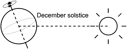
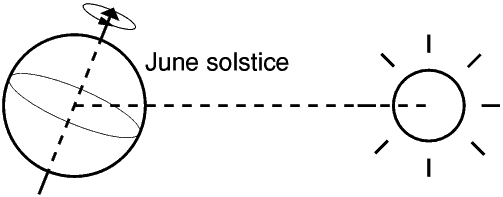
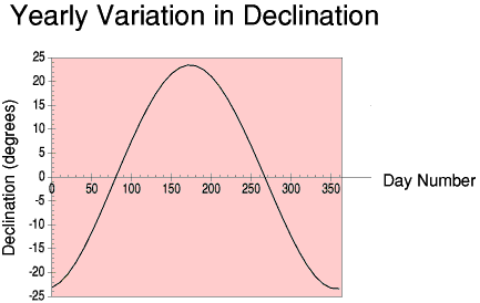
This change is represented by the term DECLINATION. The declination angle is the angle between the ecliptic and the equatorial plane.
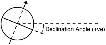
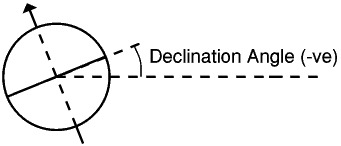
The declination changes throughout the year
The latitude of a location is defined as the angle between a line joining the location to the earth's centre and
the equatorial plane.
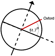
The equator is a convenient reference from which to measure latitude: the earths axis is the normal to this plane. Locations above this plane (ie northern hemisphere) are generally considered to be positive whilst those below (southern hemisphere) are negative.

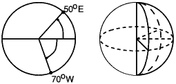
A location needs to be specified horizontally. A reference for this is less obvious but is taken as a semicircular plane, perpendicular to the equatorial plane and passing through Greenwich. Longitude is defined as the angle between this reference and a similar semicircle passing through the location. No consistent convention of positive and negative longitude exists.
All locations at the same latitude experience the same geometrical relationship with the sun. Any differences are acountable by local climate and differences in atmospheric composition.
At a local level we can think of the earth as being flat.

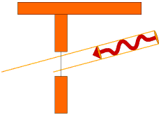
It is usual to describe the relationship between solar radiation at any location in solar time. This is a time scale in which 12 noon is the time at which the radiation arrives perpendicular to the earths surface (ie from the South or North depending on latitude and time of year). Solar noon occurs at the same time for any location with the same longitude.
 |
 |
 |
 |
Solar noon will occur 1 hour earlier for every 15 degrees east and 1 hour later for every 15 degrees west.
Time Zones are based on the MEAN Solar Time at a specific longitude. For example UK time is based on the MEAN Solar Time at 0o.The Equation of Time takes account of seasonal differences.

For Example: Solar Time for
Swansea(4oW) = Local Time - 4x4 + EOT minutes
Great Yarmouth(2oE) = Local Time + 2x4 + EOT minutes
note this is correct only for Winter/Spring when local time is Greenwich Mean Time. Subtract a further hour in Summer/Autumn.An office building in Swansea is in use from 8am until 6pm. When is the earliest and latest in Solar Time at which it will be used?
Earliest Solar Time will occur in the summer.

Earliest occupation will occur at:
08.00 - 0.16 - 0.07 - 1.00
Latest occupation will occur at:
18.00 - 0.16 + 0.17
We can easily derive the angle at which solar radiation reaches the earths surface at solar noon.
When declination is zero (March/September Equinox), this is simple:

More generally:
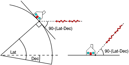
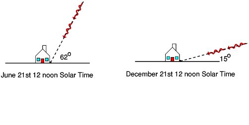
Thus for Oxford (51.7oN), solar radiation will arrive at a vertical angle of approximately 15o in the middle of winter up to approximately 62o in the middle of summer.
The sun appears hotter in the 'summer than in the 'winter'. There are two reasons for this:1. Solar radiation has to pass through more atmosphere in the winter than the summer.
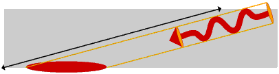
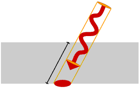
2. The solar radiation is spread over a larger area in winter than in summer.

However, radiation on a vertical surface may be more concentrated in the winter and captured within a building by being transmitted through the windows
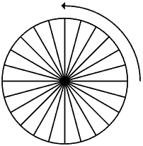
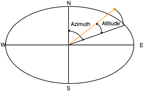
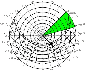
The vertical angle at which radiation approaches is referred to as the altitude. This varies throughout the day as does the direction from which it arrives (azimuth).
These may be plotted on a set of Cartesian Axes for different days of the year.
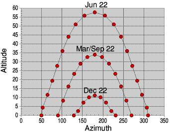
However, it is more useful to plot these on special axes with lines of constant altitude as concentric circles and lines of constant azimuth as radial lines
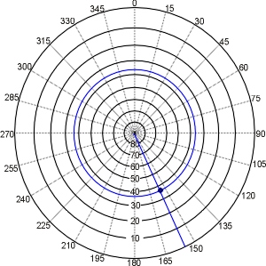
This is the Stereopathic SunPath Diagram. This example is for 52oNorth

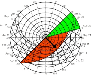
The Stereopathic SunPath Diagram can be used to assess the performance of shading devices and to assess the extent of overshadowing caused by other buildings. The shadow Angle Protractor is a useful additional tool.

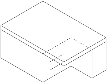
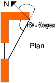
Here a building with South-East facing window has an overhanging roof to shade it from high sun angles and adjacent wall to shade from the east
To assess a vertical shading device then the vertical shadow angle is determined.
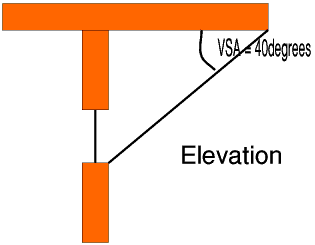
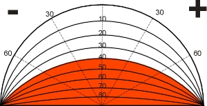
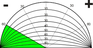
This may be marked on the Shadow Angle Protractor
Similarly, a side fin provides shading in azimuth. The corresponding Horizontal Shadow Angle may be determined using the protractor
This may be marked on the Shadow Angle Protractor
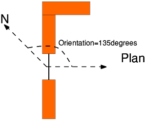
The Orientation should be noted when transferring the protractors to the SunPath diagram
The Vertical Shadow Mask may be transferred to the SunPath diagram.
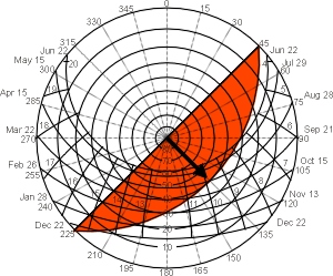
The Horizontal Shadow Mask may be transferred to the SunPath diagram.
And the combination
Many Building Simulation Tools negate the need for the use of SunPath diagrams for the assessment of shading devices.
They are however still useful design tools.
Computer Programs do exist to take the tedium out their use for example
SolRpath
Some simple solar geometry software is available online, for example SunAngle
![]()
![]()
![]()
![]()
Solar Radiation
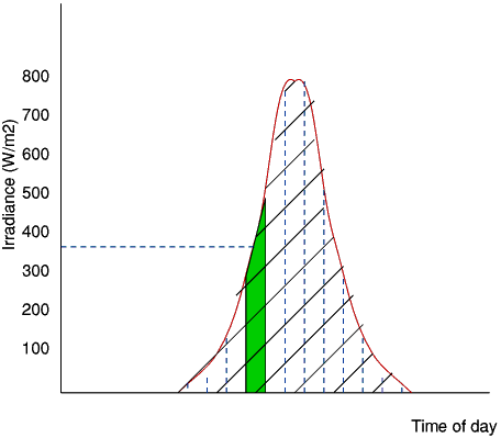
The solar radiation which arrives just outside the earths atmosphere is called "extraterrestrial radiation". Not all of this radiation will reach the earths surface. During its travel through the atmosphere:


| Szokolay S | Environmental Science Handbook | 1980 | Construction Press |
| Olgyay A & Olgyay V | Solar Control and Shading devices | 1957 | Princeton University Press |
| Szokolay S | Solar Geometry PLEA Notes | 1996 | |
| Muneer T | Solar Radiation and Daylight Models for the energy efficient design of buildings | 1997 | Butterworth-Heinemann |
| Harkness EL & Mehta ML | Solar Radiation Control in Buildings | 1978 | Applied Science |
| Duffie JA & Beckman WA | Solar Engineering of Thermal Processes | 1991 | Wiley |